
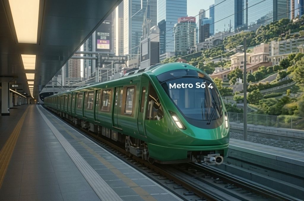
HCMC Metro Line 4, connecting Dong Thanh to Hiep Phuoc, is being studied as a North-South radial urban railway axis. The line is expected to pass through Dong Thanh, Thanh Xuan, Go Vap, Tan Son Nhat airport, Phu Nhuan, Ben Thanh center, Khanh Hoi, Nguyen Huu Tho, Nha Be, and Hiep Phuoc port urban area.
According to the environmental impact assessment consultation dossier published by HCMC authorities in 2026, the line has a length of about 43 km, including 18.2 km underground and 24.8 km elevated. The entire route is expected to feature 30 stations, two depots, and multiple transfer stations connecting with other urban railway lines.
Not only taking on the role of high-capacity passenger transport, Metro Line 4 is also expected to create a new urban development corridor, supporting the connection between Tan Son Nhat airport, the city center, and South HCMC. However, the project is currently still in the research phase, finalizing the feasibility study report, environmental assessment, and investment preparation procedures; it has not yet entered the official construction phase.
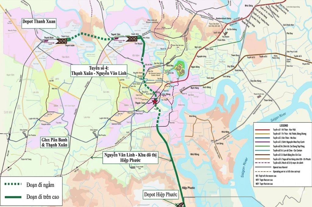
Overview of HCMC Metro Line 4
The plan being studied in 2026
The environmental impact assessment consultation dossier published in May 2026 utilizes the following plan:
- Length of approximately 43 km.
- Approximately 18.2 km underground.
- Approximately 24.8 km elevated.
- A total of 30 stations.
- Two depots at Dong Thanh and Hiep Phuoc.
Route Alignment of Metro Line 4: Dong Thanh – Hiep Phuoc
Metro Line 4 is expected to start from Cau Sang station in Dong Thanh commune and end at Hiep Phuoc station in Hiep Phuoc commune.
According to the environmental impact assessment dossier, the basic route alignment goes along the following axes:
Planned road in Dong Thanh – Ha Huy Giap – Nguyen Oanh – Truong Son – Nguyen Van Troi – Hai Ba Trung – Le Loi – Tran Hung Dao – De Tham – Khanh Hoi – Nguyen Huu Tho – Nguyen Van Tao – Planned road in Hiep Phuoc.
This is a North-South radial transport corridor connecting areas with high population density, commerce, and major travel demands in HCMC. The line simultaneously approaches the Tan Son Nhat airport hub, Ben Thanh central area, South Saigon urban area, and Hiep Phuoc area.
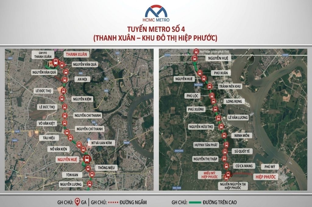
Which wards and communes does Metro Line 4 pass through?
Dong Thanh, Thoi An, An Phu Dong, An Nhon, Go Vap, Hanh Thong, Tan Son, Tan Son Hoa, Tan Son Nhat, Duc Nhuan, Phu Nhuan, Cau Kieu, Tan Dinh, Xuan Hoa, Sai Gon, Ben Thanh, Cau Ong Lanh, Vinh Hoi, Khanh Hoi, Tan Hung, Nha Be, Hiep Phuoc.
This list is compiled based on the boundaries and names of administrative units used in the project dossier at the time of publication. The detailed boundaries of the project, station entrances/exits, depot areas, and the scope of land clearance will only be accurately determined after finalizing the design and setting project landmarks.
List of 30 expected stations of Metro Line 4
According to the 2026 plan, Metro Line 4 is expected to feature 30 stations:
The specific names and locations of the stations may continue to be adjusted during the appraisal of planning, feasibility reports, and technical design.
Important transfer points
Metro Line 4 is expected to have 11 transfer stations connecting with other urban railway lines. Notable connection points include:
Tan Son Nhat – Hoang Van Thu Area
This is the connection area between Metro Line 4, Tan Son Nhat Airport, and urban railway lines related to the airport corridor. The station in this area can become one of the major passenger hubs of the entire line.
Ben Thanh Area
Ben Thanh Station is oriented to be the central station of the HCMC metro network. Line 4 passing through this area will increase the transfer capacity between the North-South axis with the East-West lines and other railway corridors.
Khanh Hoi – Nguyen Huu Tho Area
The Southern section is expected to coordinate with the Ben Thanh – Can Gio high-speed railway line and major transport projects along the Nguyen Huu Tho corridor.
Hiep Phuoc Area
The terminal stations support the connection of the urban area, industrial park, logistics, and Hiep Phuoc port with the city center area.
Technology and transport capacity
Metro Line 4 is studied according to double-track standards, electrified, and utilizes a 1,435 mm track gauge.
Expected design speed:
- Maximum 120 km/h for the elevated section.
- Maximum 90 km/h for the underground section.
- Axle load of about 16 tons/axle.
- Train configuration from 3 to 6 cars depending on the phase.
- Expected headway from 2.2 to 4 minutes.
Forecasted passenger transport capacity:
- Year 2030: about 15,360 passengers/hour/direction.
- Year 2040: about 29,330 passengers/hour/direction.
- Year 2050: about 40,100 passengers/hour/direction.
The operation plan is studied based on a model combining long-haul routes serving the entire line and short-haul routes to increase frequency in the central area with high passenger density.
Two depots of Metro Line 4
The project is expected to arrange two depot areas:
Dong Thanh Depot
The Northern depot is located in Dong Thanh commune, serving the assembly, operation, repair, and maintenance of trains for the beginning section of the line.
Hiep Phuoc Depot
The Southern depot is located in Hiep Phuoc commune, supporting line exploitation, vehicle maintenance, and coordinating activities at the end section of the line.
In addition to the two depots, the project is expected to have three main power substations. Two stations will be arranged at the depot areas and one station to the West of Hoang Van Thu Park Station.
Total investment of Metro Line 4
The preliminary total investment of Metro Line 4 is cited by some dossiers and press agencies at approximately 157,400 billion VND, equivalent to over 5.9 billion USD at the time of conversion.
The project is being studied for implementation under the Public-Private Partnership (PPP) method or other investment methods in accordance with legal regulations. The financial plan may combine land fund exploitation, Transit-Oriented Development (TOD), and other legal capital sources.
The 157,400 billion VND figure is merely an initial estimate. The official total capital will also depend on the tunnel length, number of stations, train technology, site clearance costs, loan interest, contingencies, investment timing, and the appraisal results of the feasibility report.
Latest progress of Metro Line 4 updated in 2026
June 2025: Sovico proposes investment research
Sovico proposed researching Metro Line 4 with a plan of about 47.32 km long, featuring 37 stations and two depots. The HCMC People’s Committee assigned departments and agencies to review the enterprise’s proposal.
October 2025: Signing a project development cooperation memorandum
The HCMC People’s Committee and Sovico signed a memorandum of cooperation regarding the research and development of Metro Line 4. This event paved the way for the enterprise to continue researching the route alignment, investment method, and financial structure of the project.
Early 2026: Finalizing the route alignment plan
Sovico continued to submit the route alignment plan and facility locations to the HCMC planning authority. The plan was updated according to the new administrative boundaries and determined the route passing through 22 wards and communes.
May 2026: Deploying the preparation of the feasibility study report
The joint venture including Guangzhou Metro Design & Research Institute (GMDI), Arup Vietnam Company Limited, and Transport Engineering Design Inc. South (TEDI SOUTH) participated in preparing the feasibility study report for the project.
May–June 2026: Environmental impact assessment consultation
The HCMC Department of Agriculture and Environment published the consultation dossier for the project’s environmental impact assessment report, with a deadline for receiving feedback until June 2, 2026.
This is a crucial step in the project preparation process, aimed at evaluating the impact of site clearance activities, tunnel, viaduct, station, and depot construction, as well as line operation on residential areas, the canal system, urban environment, and sensitive areas.
Goal to commence in 2027
The environmental consultation dossier stated the expected construction commencement progress in Q1–Q2/2027. Sovico previously set the goal of completing the feasibility study report in 2026 and aimed to break ground in Q1/2027.
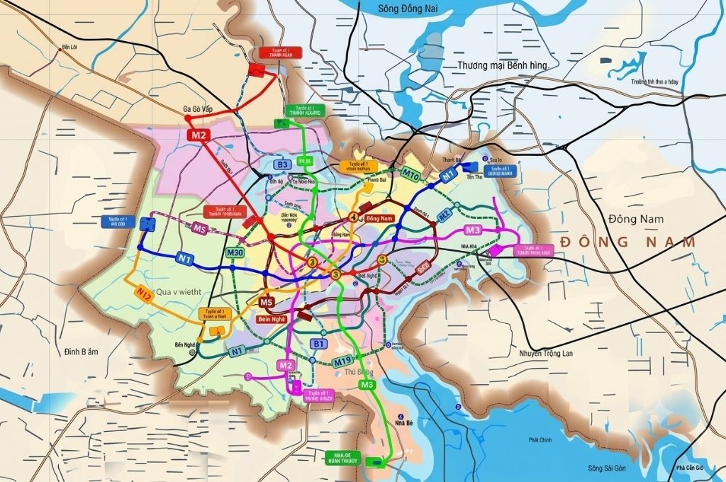
The role of Metro Line 4 in HCMC’s transport system
Forming a North-South transport axis
Metro Line 4 creates a high-capacity public transport corridor from Dong Thanh and Thanh Xuan through Go Vap, Phu Nhuan, the city center to Nha Be and Hiep Phuoc.
The line helps reduce pressure on frequently high-traffic axes such as Ha Huy Giap, Nguyen Oanh, Nguyen Van Troi, Hai Ba Trung, and Nguyen Huu Tho.
Increasing accessibility to Tan Son Nhat airport
Stations in the airport area and Hoang Van Thu Park can assist in organizing a passenger transit system, reducing the volume of personal vehicles approaching the airport.
Connecting the metro network
With 11 expected transfer stations, Metro Line 4 does not operate as an independent line but becomes part of an integrated urban railway network.
Supporting South area development
The section from Khanh Hoi through Nguyen Huu Tho, Nha Be to Hiep Phuoc supports connecting Southern residential areas, urban areas, logistics, industries, and seaports with the center of HCMC.
Promoting green transport
Shifting a portion of travel demand from motorbikes and cars to urban railways can contribute to reducing congestion, fuel consumption, and traffic emissions if the line achieves a sufficiently large passenger volume.
The impact of Metro Line 4 on the real estate market
Metro Line 4 can exert a significant influence on the urban development structure along the North-South corridor.
Dong Thanh – Thanh Xuan Area
The terminal stations and depots can provide momentum to improve connectivity for the Northern area of the city. Land plots with clear legality, located in existing residential areas, and with convenient access to stations will have an advantage over plots that are merely near the route alignment on the map.
Go Vap – Tan Son Nhat – Phu Nhuan Area
The terminal stations and depots can provide momentum to improve connectivity for the Northern area of the city. Land plots with clear legality, located in existing residential areas, and with convenient access to stations will have an advantage over plots that are merely near the route alignment on the map.
Go Vap – Tan Son Nhat – Phu Nhuan Area
This is an area with high population density, commerce, and major travel demands. The land fund for new development is relatively limited, so the impact may be more evident in the capabilities of commercial, office, and rental apartment exploitation and urban renovation around the stations.
Ben Thanh – Khanh Hoi Area
The main advantage is the ability to transit and access the central area. Real estate values here are already at a high level, so the metro may have a greater impact on exploitation functionality and liquidity rather than causing across-the-board price increases.
Nguyen Huu Tho – Nha Be Area
Metro Line 4 adds a crucial public transport axis to the South area, where there are many large-scale housing and urban projects. Actual effectiveness depends on the location of station entrances/exits, bus connections, road bridges, and the completion progress of the entire route. The most benefiting projects include Arcadia at Lavila, TT Genesis, …… and other projects preparing for deployment.
Hiep Phuoc Area
The terminal stations can support the development of port urban areas, logistics, services, and industrial zones. This is a long-term impact, tied to the Hiep Phuoc master plan and the ability to form TOD urban areas around the stations. Benefiting projects include Hiep Phuoc Premia, T&T, ……..
TOD Urban Development along Metro Line 4
TOD – Transit-Oriented Development is an urban development model centered around public transport hubs.
For Metro Line 4, TOD can be studied in areas with:
- Transfer stations between multiple lines.
- Land funds large enough for urban restructuring.
- Bus and pedestrian connection capabilities.
- Demand for housing, commercial, and office development.
- Conditions to exploit underground space and space around stations.
Areas like Dong Thanh, Thanh Xuan, Tan Son Nhat, Ben Thanh, Nguyen Van Linh, Nha Be, and Hiep Phuoc can be considered under various TOD models. However, the official TOD scope must be based on approved planning and should not be determined merely on self-estimated radii around station locations.
Frequently Asked Questions about HCMC Metro Line 4
Conclusion
The Dong Thanh – Hiep Phuoc Metro Line 4 is one of the urban railway projects playing a crucial role in HCMC’s future transport network. With an under-study length of about 43 km, 30 stations, and two depots, the line will form a radial public transport axis from the North through Tan Son Nhat airport, Ben Thanh center to the South and Hiep Phuoc.
In 2026, the project has taken a further step with the preparation of the feasibility study report, finalization of the route alignment, and organizing the environmental impact assessment consultation. The goal of breaking ground in 2027 is a notable signal, but it still depends on appraisal results, capital sources, investor selection, and site clearance activities.