
Overview of Ho Chi Minh City Metro Line 7
Ho Chi Minh City Metro Line 7 is planned as a radial urban railway axis connecting the Southwest area with the South area, Thu Thiem New Urban Area, and the East of the city. The line is expected to start at Tan Kien node, pass through the Nguyen Van Linh corridor, Phu My Hung, Thu Thiem, Thao Dien, Thanh Da, Truong Tho, High-Tech Park, and end at the Vinhomes Grand Park – Long Binh area.
According to the announced planning, Metro Line 7 has a length of about 51.23 km, including 16.5 km underground and 34.73 km elevated; the entire line is expected to have 34 stations and two depots. An important update in 2026 is that the route through Thu Thiem has been adjusted to Bui Thien Ngo – To Huu streets to directly access the new Political – Administrative Center of Ho Chi Minh City.
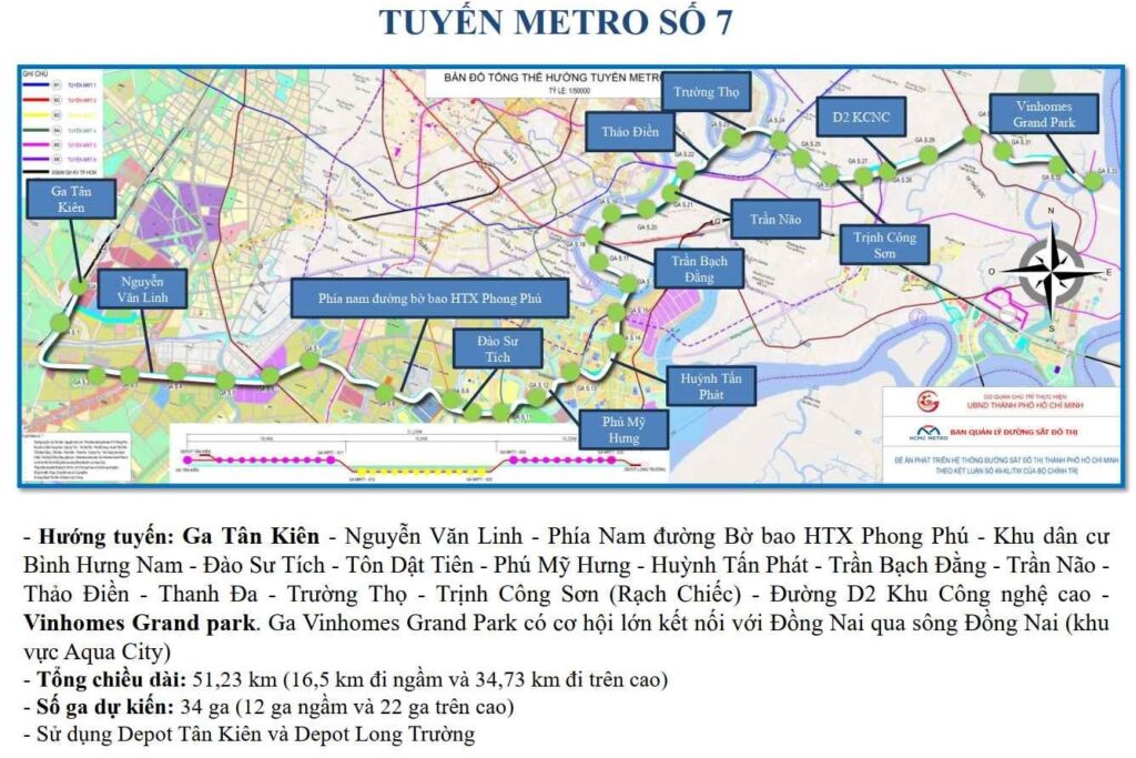
Where does HCMC Metro Line 7 go through?
According to the previously announced route and the new adjustment in Thu Thiem, Metro Line 7 is expected to pass through the following main corridors:
Tan Kien Station → Nguyen Van Linh Street → South of Phong Phu Cooperative Embankment Street → Binh Hung Nam Residential Area → Dao Su Tich Street → Ton Dat Tien Street → Phu My Hung Urban Area → Huynh Tan Phat Street → Thu Thiem 4 Bridge Area → Bui Thien Ngo Street → To Huu Street → Tran Nao Street → Thao Dien → Thanh Da → Truong Tho → Rach Chiec Area – Trinh Cong Son Street → D2 Street High-Tech Park → Vinhomes Grand Park → Eastern depot area.
The entire line can be divided into five main development sections.
Tan Kien – Nguyen Van Linh Section
The starting point of Metro Line 7 is located at the Tan Kien node area, which is oriented to develop into a major transportation hub in the Southwest of HCMC. This area has the potential to connect with the extended Metro Line 1 towards An Ha, Metro Line 3, and the national railway system in the future.
From Tan Kien, the line heads to the Nguyen Van Linh corridor, serving the Binh Chanh area and developing residential areas along the Southwest gateway.
Phong Phu – Binh Hung – Phu My Hung Section
After approaching the South of Phong Phu Cooperative Embankment Street, the line is expected to pass through the Binh Hung Nam residential area, Dao Su Tich Street, Ton Dat Tien Street, and Phu My Hung Urban Area.
This section plays a role in connecting Southern residential areas with the commercial, financial, service, and office centers in Phu My Hung. Metro Line 7 can also provide an additional high-capacity public transport option for the Nguyen Van Linh corridor, which is facing increasing traffic pressure.
Phu My Hung – Huynh Tan Phat – Thu Thiem Section
From Phu My Hung, the line continues through the Huynh Tan Phat area towards Thu Thiem 4 Bridge. This segment directly connects the South area with the Thu Thiem New Urban Area, instead of passengers having to travel through the existing central area.
The formation of Metro Line 7 along with Thu Thiem 4 Bridge can create a new public transport corridor between Saigon South and the new central area on the East side of the Saigon River.
Thu Thiem – Thao Dien – Thanh Da – Truong Tho Section
After passing through Thu Thiem, the line is expected to merge into Tran Nao Street, approaching Thao Dien, Thanh Da, and Truong Tho.
This is one of the most complex sections of the project as it passes through a highly urbanized area with many rivers, canals, and existing residential areas. The final technical plan will have to simultaneously address requirements for river crossing, underground station layout, transit connections, and minimizing impact on existing structures.
Rach Chiec – High-Tech Park – Vinhomes Grand Park Section
From Truong Tho, Metro Line 7 is expected to head towards the Rach Chiec area, Trinh Cong Son Street, D2 Street in the High-Tech Park, and end at Vinhomes Grand Park before connecting to the Eastern depot.
This segment has the potential to serve a large number of workers in the High-Tech Park and residents in urban areas in East HCMC.
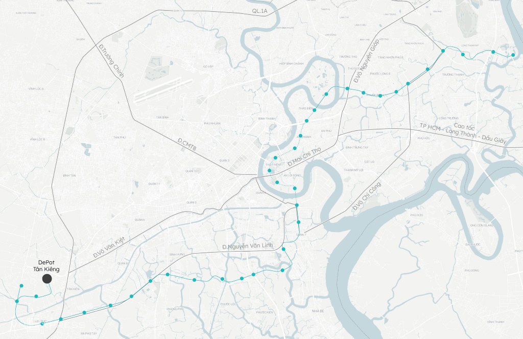
How is the route of Metro Line 7 adjusted through Thu Thiem?
The most notable update in 2026 is HCMC adjusting the route of Metro Line 7 through the Thu Thiem New Urban Area.
According to Decision No. 989/QD-UBND on the local adjustment of the general planning of the old Thu Duc City area to 2040, Metro Line 7 from the Thu Thiem 4 Bridge area will no longer run along Tran Bach Dang Street as previously planned. The route is adjusted to follow:
Thu Thiem 4 Bridge → Bui Thien Ngo Street → To Huu Street → merging into Tran Nao Street.
Several station locations on this section have also been adjusted to synchronize with the new route.
Why was Metro Line 7 moved to To Huu Street?
The main goal of realigning the route is to allow Metro Line 7 to directly access the new Political – Administrative Center of HCMC, expected to be built in Thu Thiem.
This central area has a scale of about 7.84 hectares, located along To Huu Street and facing the central square. Routing Metro Line 7 underground through this area increases accessibility by public transport while connecting the administrative center with the South area, Binh Chanh, and the East of the city.
The section of Metro Line 7 passing through the Thu Thiem New Urban Area alone is expected to have about six stations.
The scale of 34 stations of Metro Line 7
Metro Line 7 is expected to have a total of 34 stations, including:
- 12 underground stations.
- 22 elevated stations.
- About 6 stations within the Thu Thiem New Urban Area.
- Two depots in Tan Kien and Long Truong.
With a length of approximately 51.23 km and 34 stations, the theoretical average distance between stations is about 1.5 km. The actual distance may vary depending on population density, geological conditions, traffic connectivity capabilities, and land use planning of each area.
Which railway lines does Metro Line 7 connect with?
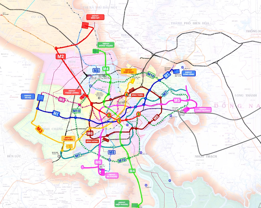
Based on the network structure, Metro Line 7 is oriented to become a radial line connecting many important hubs.
Connection at Tan Kien
Tan Kien is planned as a transportation hub in the Southwest, capable of connecting Metro Line 7 with the extended Metro Line 1 to An Ha, Metro Line 3, and national railway lines.
Connection at Thu Thiem
Metro Line 7 is capable of organizing transfers with Metro Line 2 on the Ben Thanh – Thu Thiem section. Both lines are planned to run underground through the new Political – Administrative Center area.
Connection in the Thao Dien – Truong Tho area
The Thao Dien – Truong Tho corridor is located near Metro Line 1 (Ben Thanh – Suoi Tien) and many future planned urban railway lines. Specific transfer capabilities still depend on the station locations and approved connection designs.
Connection at High-Tech Park and Long Binh
The Eastern endpoint helps Metro Line 7 access the High-Tech Park, Vinhomes Grand Park, and the Long Binh area. This is a region with a high density of jobs and population, creating a foundation for passenger demand for the line.
Metro Line 7 progress updated in 2026
Metro Line 7 was established in the HCMC Planning for the 2021-2030 period, with a vision to 2050 approved by the Prime Minister in Decision No. 1711/QD-TTg on December 31, 2024.
On February 19, 2025, the National Assembly issued Resolution No. 188/2025/QH15 on piloting specific mechanisms and policies to develop the urban railway system in Hanoi and HCMC. This mechanism allows shortening some investment preparation procedures, promoting TOD, mobilizing capital, and organizing the synchronous implementation of the metro network.
According to information announced by the HCMC Department of Construction, the city has assigned the Management Authority for Urban Railways to prepare for the investment of seven lines from Metro Line 1 to Metro Line 7. The common goal is to complete compensation, support, and resettlement in 2027, strive to simultaneously commence construction of the remaining lines from the end of 2027, and complete about 355 km of urban railways by 2035.
Proposal to invest in Metro Line 7 under the PPP model
In February 2026, a consortium including Kita Group Joint Stock Company, Vietnam Railway Construction Corporation, and Trung Chinh Trading Co., Ltd. proposed that the HCMC People’s Committee allow research, surveying, and preparation of an investment proposal for Metro Line 7 under the public-private partnership (PPP) model.
According to the consortium’s proposal:
- The project is proposed to be implemented under the PPP model.
- The consortium commits to preparing the investment proposal dossier in June 2026.
- The total preparation and implementation time is estimated by the investor to be about 42 months.
- The construction time is proposed to be about 26 months.
The investors commit to contributing enough equity and mobilizing legal capital sources if the project is approved.
How much is the total investment capital for Metro Line 7?
As of the updated time, the official total investment of Metro Line 7 has not been announced at the approved project level.
Strategic role of Metro Line 7
Forming the Southwest – South – East traffic axis
Metro Line 7 creates a continuous public transport corridor from Binh Chanh through Saigon South to Thu Thiem and the East. The line provides an additional travel option that does not require transferring through Ben Thanh.
Connecting major urban centers
The line is expected to serve many important development poles:
- Tan Kien hub.
- Nguyen Van Linh corridor.
- Phu My Hung Urban Area.
- Thu Thiem New Urban Area.
- New Political – Administrative Center.
- Thao Dien and An Phu.
- Truong Tho Urban Area.
- High-Tech Park.
- Vinhomes Grand Park and Long Binh.
Helping to reduce road traffic pressure
When synchronously formed with buses and other metro lines, Metro Line 7 can share travel demand on Nguyen Van Linh, Huynh Tan Phat, the connecting axes of the South area – Thu Thiem, Tran Nao, and Eastern routes.
Promoting urban development according to the TOD model
Resolution 188/2025/QH15 and HCMC’s implementation plan create a basis for developing transit-oriented urban areas around the stations.
TOD can help the city exploit land funds, reorganize urban spaces, and develop housing, commerce, offices, and services within convenient access to the metro.
Impact of Metro Line 7 on real estate
According to the route and TOD development principles. The actual level of benefit for each project also depends on the official station location, walking distance, construction progress, and project legalities.
Tan Kien – Binh Chanh Area
Tan Kien has the potential to become a major transportation hub in the Southwest. Metro Line 7 combined with other metro lines and national railways can facilitate the development of urban areas, services, and logistics.
Nguyen Van Linh – Phong Phu – Binh Hung Corridor
Residential areas located near actual station locations can improve connectivity to Phu My Hung, Thu Thiem, and the East.
Ongoing projects near stations and the passing route benefit and are re-priced, such as TT Genesis on Dao Su Tich Street, and upcoming projects.
Phu My Hung Urban Area
Phu My Hung is a relatively fully developed urban area. Metro Line 7 can help increase accessibility, attracting tenants, workers, and customers to commercial centers, offices, education, and healthcare facilities.
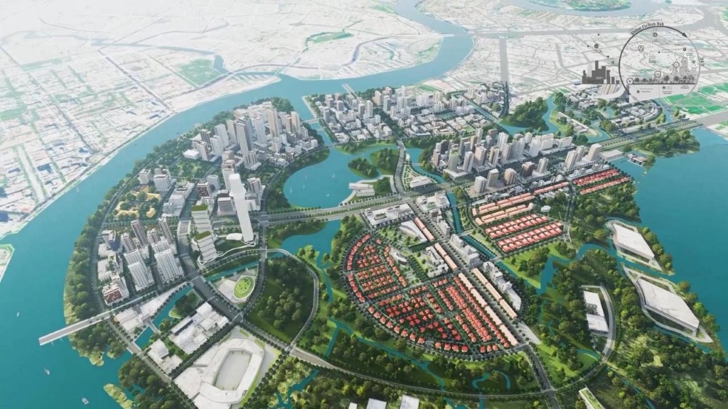
Thu Thiem New Urban Area
Adjusting Metro Line 7 through To Huu Street increases the public transport role of the new Political – Administrative Center area.
Thu Thiem has the potential to become a convergence point for Metro Line 2, Metro Line 7, and many other transport projects. However, infrastructure expectations are often reflected in real estate prices early on, so careful assessment is needed rather than relying solely on planning information.
Thao Dien – Thanh Da – Truong Tho
This area has the advantage of being located near many urban railway corridors. Metro Line 7 can support direct connections to the South area, Thu Thiem, and the High-Tech Park.
High-Tech Park – Vinhomes Grand Park
This is an area with relatively clear travel demand from the workforce at the High-Tech Park and the large-scale resident community in Vinhomes Grand Park.
Frequently Asked Questions about HCMC Metro Line 7
Conclusion
Metro Line 7 plays a particularly strategic role because it continuously connects three major development spaces in HCMC: the Southwest area, Saigon South, and the East.
Adjusting the route through the new Political – Administrative Center in Thu Thiem increases the line’s role in the future urban structure. At the same time, interest from the private sector shows that the project has the ability to attract various capital mobilization plans.