
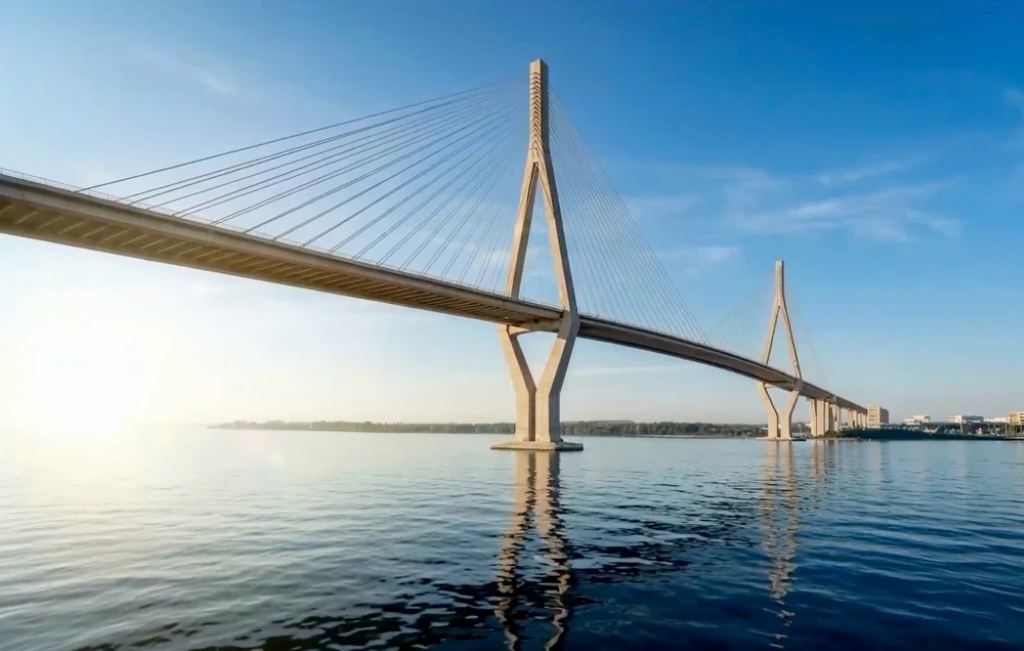
PHU MY 2 BRIDGE
As one of the most notable inter-regional transport projects in the Southeast region. With a total length of about 6.3 km, an 8-lane scale, and a total investment of over 23,185 billion VND, the project is oriented to form a new connection route between the South of HCMC, the Southern area of Dong Nai province, and Long Thanh International Airport.
Not only adding a river-crossing route, Phu My 2 Bridge is also expected to contribute to relieving the load on the existing Phu My Bridge, National Highway 1, National Highway 51, and the HCMC – Long Thanh – Dau Giay expressway. When the approach roads at both ends of the bridge are synchronously invested, the project will create a continuous traffic corridor between the center of HCMC, Tan Son Nhat Airport, the South of the city, Dong Nai, and Long Thanh Airport.

The project scope passes through Phu Thuan ward, Tan My ward, Nha Be commune in HCMC and Dai Phuoc commune in Dong Nai province. In older documents, the Dong Nai side area is often referred to as Nhon Trach district.
Where is Phu My 2 Bridge located?
The starting point of Phu My 2 Bridge is determined at the Nguyen Huu Tho axis, one of the important traffic routes connecting the center of HCMC with the South of the city. From here, the route passes through the Hoang Quoc Viet area, connecting with Dao Tri street before crossing the river to Dai Phuoc commune, Dong Nai province.
On the Dong Nai side, the bridge approach road connects to Lien Cang street. According to the local infrastructure orientation, this route will continue to be connected to Provincial Road 25C, thereby creating a traffic flow to the Nhon Trach area and Long Thanh International Airport.
This is a route with special significance for the South of HCMC. Instead of relying mainly on the HCMC – Long Thanh – Dau Giay expressway or the existing Phu My bridge route, vehicles can access Dong Nai via a new traffic corridor located to the South.
Main connection direction of Phu My 2 Bridge
Nguyen Huu Tho → Hoang Quoc Viet → Dao Tri → Phu My 2 Bridge → Lien Cang road → 25C road → Long Thanh airport.
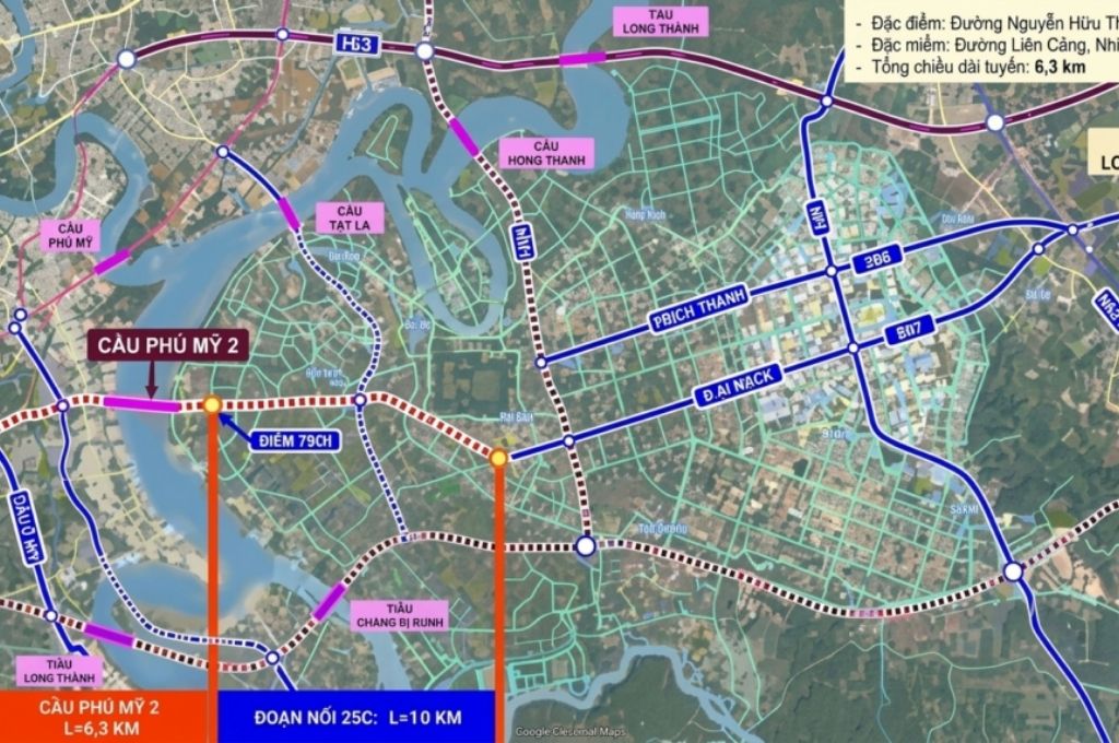
When all connecting sections are completed, this will be one of the direct travel options from the South of HCMC to the Nhon Trach area and Long Thanh airport. However, the actual efficiency still depends on the progress of Lien Cang road, 25C road, and related intersections.
8-lane scale and multi-level road design
Phu My 2 Bridge is planned with the bridge section comprising 8 lanes, including 6 lanes for cars and 2 mixed-use lanes. The approach roads at both ends are also invested with a minimum cross-section of 8 lanes to ensure synchronous traffic capacity.
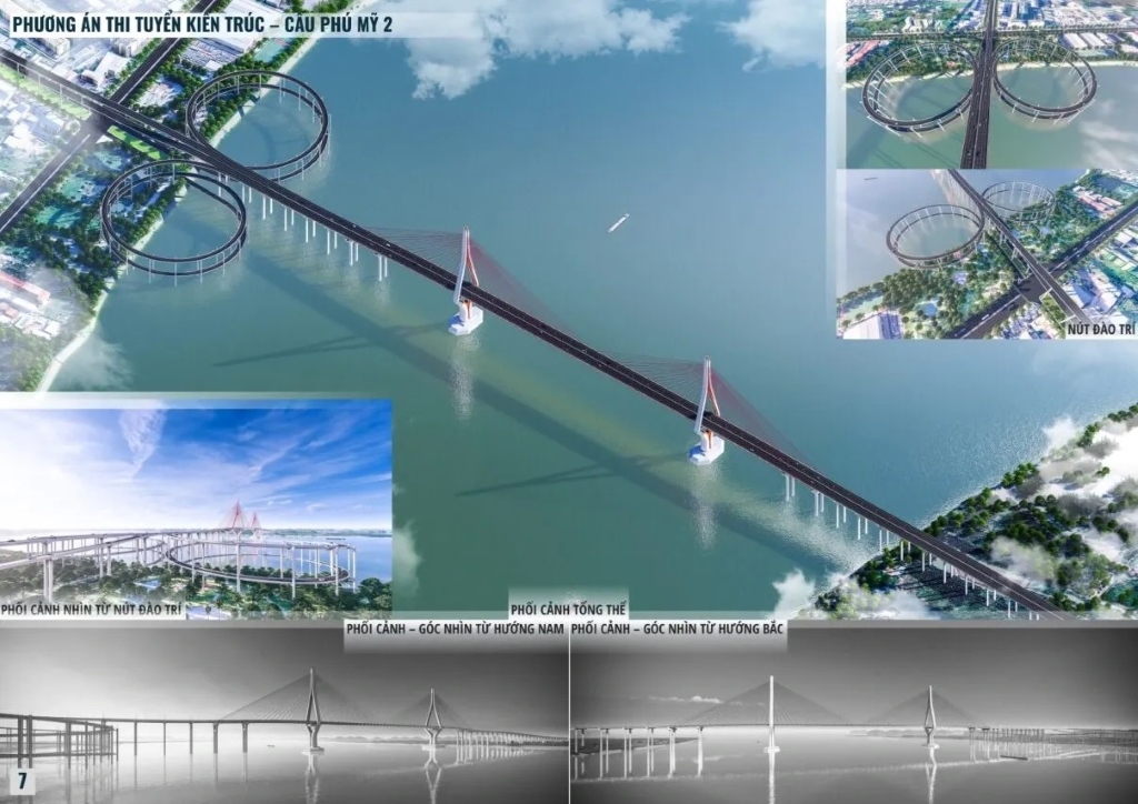
One of the most notable points of the project is the multi-level elevated road solution in the HCMC area. The bridge and approach road section, about 2 km long, is studied to be arranged with one to two levels of viaducts, running along Hoang Quoc Viet street and connecting to Dao Tri street.
This solution was chosen due to the relatively limited right-of-way of Hoang Quoc Viet street, making it difficult to expand according to traditional methods. Elevating a part of the route can reduce the site clearance area, limit the impact on residential areas, and make better use of urban traffic space. This is also considered one of the first projects in HCMC to study the application of a large-scale multi-level road model.
Architectural plan of Phu My 2 Bridge
In April 2026, the HCMC People’s Committee approved the results of the architectural design competition for Phu My 2 Bridge. The first prize went to the joint venture of Transport Engineering Design Incorporated (TEDI) and BR Design Consultant Company Limited.
The selected plan uses a cable-stayed bridge structure, an 8-lane scale, and a navigable clearance of about 55 m. The approach road on the HCMC side includes a multi-level viaduct system, while the Dong Nai side connects to Lien Cang road. After the competition, the first-prize winning unit continues to perfect the plan according to the council’s conclusion as a basis for deploying the next design steps.
The 55 m clearance helps ensure space for waterway traffic on the river. However, articles should not use the assertion “the bridge with the highest clearance in Vietnam” unless there is an official document comparing it with all other structures.
Total investment of Phu My 2 Bridge
The total investment approved by the HCMC People’s Council for the project is about 23,185.6 billion VND, including loan interest. This is the most suitable figure to use in the title, overview section, and project information board.
Implementation under the PPP method and BT contract allows mobilizing non-state resources to invest in the construction, then transferring the structure to the State according to the project contract and the approved payment plan.
Latest progress of Phu My 2 Bridge in 2026
The project has passed several important milestones:
- December 26, 2025: HCMC People’s Council approved the investment policy in Resolution 521/NQ-HDND.
- January 15, 2026: HCMC held the groundbreaking ceremony for the project.
- March 2026: Dong Nai province participated in commenting on the appraisal of the feasibility study report.
- April 2026: The results of the architectural design competition were approved.
- The construction phase of the project is expected from 2026 to 2029.
When will Phu My 2 Bridge be completed?
According to the investment policy, the construction time of the BT project is expected to last from 2026 to 2029. After completion and handover, the BT project payment process is expected to continue for about 3 years.
Thus, the current goal is to complete the construction and put it into operation in 2029. This is still an expected plan; the actual milestone will depend on the progress of project approval, contract signing, site clearance, resource allocation, and construction deployment.
Role in connecting to Long Thanh Airport
Phu My 2 Bridge is oriented to become a link in the traffic corridor connecting Tan Son Nhat Airport, the center of HCMC, and Long Thanh Airport.
From the city center, vehicles can move along the North – South axis and Nguyen Huu Tho street, approach Phu My 2 Bridge, then pass through Lien Cang road and 25C road towards Long Thanh airport.
This corridor helps supplement travel options besides the HCMC – Long Thanh – Dau Giay expressway. In particular, residents in the South of the city can access Long Thanh airport without having to detour to the Eastern gateways as they do now.
Relieving the load on existing traffic routes
According to the investment objective, Phu My 2 Bridge will support traffic flow distribution and reduce traffic pressure on many important routes including:
- The existing Phu My Bridge.
- National Highway 1.
- National Highway 51.
- HCMC – Long Thanh – Dau Giay Expressway.
- Freight transport routes through the South of HCMC.
Having an additional 8-lane river-crossing bridge helps redistribute the vehicle flow between HCMC and Dong Nai, especially for vehicles heading to the airport, industrial parks, logistics centers, and the seaport system in the region.
Phu My 2 Bridge also contributes to increasing the multimodal connectivity between road, air, and sea. This is a crucial factor for the Southern key economic region, where many seaports, industrial parks, manufacturing centers, and major import-export hubs are concentrated.
Impact on the South of HCMC and Dong Nai
Once completed, Phu My 2 Bridge can expand the urban development space to the South and Southeast, increasing accessibility between the South of HCMC with Dai Phuoc, Nhon Trach, and Long Thanh Airport.
For the South of HCMC, the project creates additional motivation to complete Nguyen Huu Tho, Hoang Quoc Viet, Dao Tri routes, and the riverside traffic system. For Dong Nai, the project supports connecting Dai Phuoc and the Nhon Trach area with the center of HCMC, while increasing the operational efficiency of Lien Cang road and 25C road.
New traffic infrastructure often generates more interest in the real estate market along the Southern routes, such as the ongoing projects like Vlasta Premier Phu Thuan, Arcadia at Lavila, TT Genesis ……
How does Phu My 2 Bridge differ from the existing Phu My Bridge?
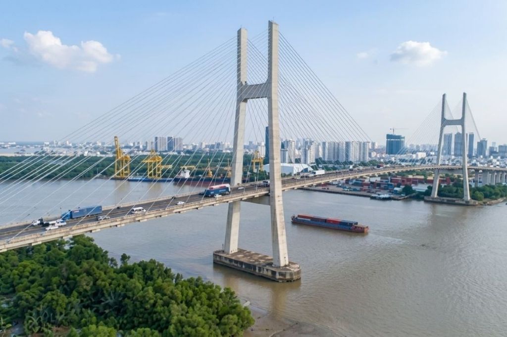
The existing Phu My Bridge is connecting the Southern area of the city with the East of HCMC and is an important part of the Ring Road 2 route.
Meanwhile, Phu My 2 Bridge is planned to cross the river to Dai Phuoc commune, Dong Nai province. The main goal is to form a new corridor from Nguyen Huu Tho street to Lien Cang road, 25C road, and Long Thanh airport.
Frequently Asked Questions about Phu My 2 Bridge
Conclusion
Phu My 2 Bridge is a strategic infrastructure project with a scale of about 6.3 km, 8 lanes, and a total investment of over 23,185 billion VND. The project not only creates a new connection direction between HCMC and Dong Nai but also contributes to forming a new traffic corridor to Long Thanh airport, the seaport system, and logistics centers of the Southeast region.
After the investment policy was approved and the groundbreaking ceremony was held, the project is continuing to perfect the feasibility study report, design, site clearance, and implementation procedures. The current goal is to complete the project in 2029.